-
- Фото: Alvov © shutterstock.com
-

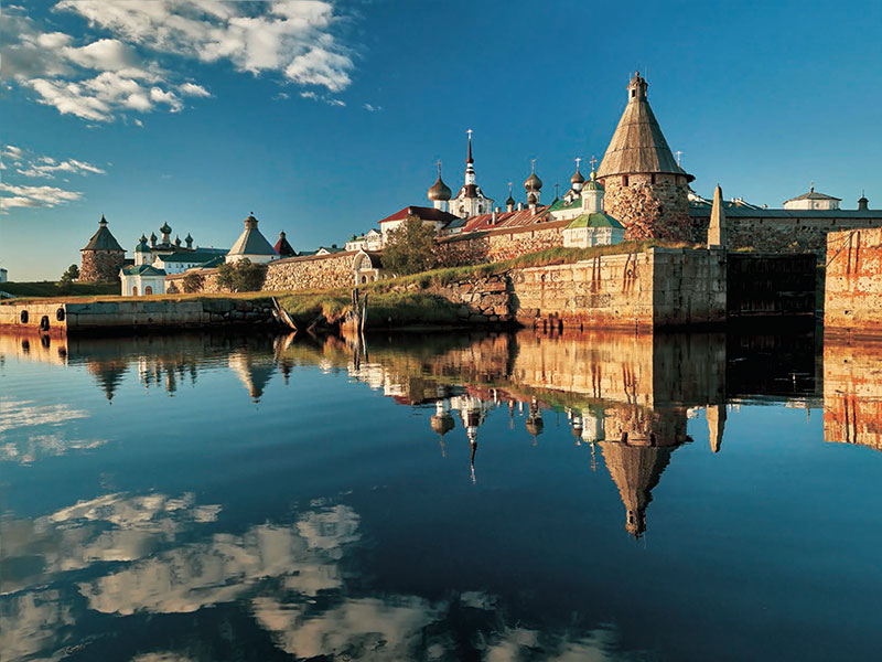
- Каменный лабиринт на Большом Заяцком острове. Stone labyrinth on Bolshoi Zayatsky Island. Фото: Piu_Piu © shutterstock.com
-
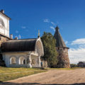
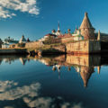
- Главный вход в монастырь — Святые врата. Main entrance to the monastery — Holy Gate. Фото: Baturina Yuliya © shutterstock.com
-
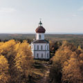
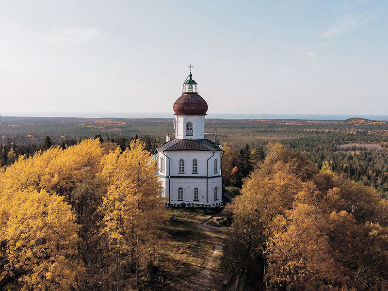
- Вознесенский скит. Храм-маяк на Секирной горе. Ascension Skete. Church-lighthouse on Sekirnaya Hill. Фото: Yakovlev Sergey © shutterstock.com
-
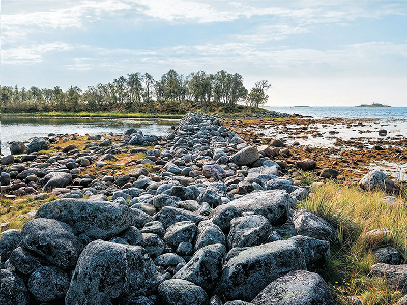
- Филипповские садки — огороженный дамбой искусственный морской залив для рыбы. Filipp fish pond, a man-made bay cut off from the sea by a wall of stones. Фото: Baturina Yuliya © shutterstock.com
-

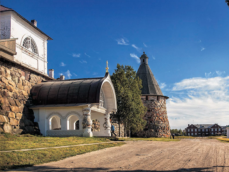
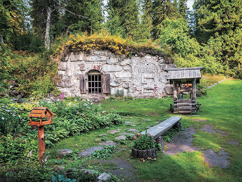
- Валунный погреб-ледник. Ice-cellar made of boulders. Фото: Baturina Yuliya © shutterstock.com
Thirty years ago, the Cultural and Historic Ensemble of the Solovetsky Islands was one of the first Russian sites to be inscribed on the UNESCO World Heritage List. The Solovetsky Archipelago comprises six large and over 200 small islands sitting on an elevated underwater bedplate which was shaped by boulder-pebble-sand glacial, aqueoglacial, and glaciolacustrine sediments dating back to the last Glacial Period.
The low population density and relatively difficult access to the area contributed to preservation of the tangible heritage and cultural landscape. However, as one culture gave way to another, the heritage was treated differently — elements of the past culture were either integrated into the new culture or became relics.
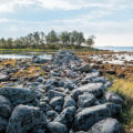
During the primeval times, the archipelago’s role was defined by its isolation and vast expanses of water that surrounded it: these features made it unlike other places. Difficult access to food made the archipelago unattractive to permanent settlers but enhanced its sacred value: inaccessibility made it difficult to destroy places of worship, there was no resident population, and extraordinary landscapes, in the minds of ancient people, commanded acknowledgment and worship. The Solovetsky Archipelago features over 20 recorded labyrinths and four shrines comprising at least 700 man-made settings: labyrinths, rockfill dams and so-called symbolic stone settings. The biggest shrine is scattered over the slopes and top of Signalnaya Mountain on Bolshoi Zayatsky Island (around 650 settings). The shrine on the Cape of Labyrinths on Anzer Island included two labyrinths and 42 rockfill dams (six of them were excavated by the Solovki archeological expedition). The Kolguevo agglomeration comprises two labyrinths and three dozen rockfill dams. The settings on the Cape of Hearth on Bolshoi Solovetsky Island were destroyed in the 1930s and restored in 1972 as an architectural model by Anatoly Kuratov’s expedition.
During the 12th-15th centuries, the Solovetsky Islands were visited by three ethnic groups who lived on the White Sea shores as suggested by archeologic and documentary evidence: the Sami, Karelians (as they were referred to in annals) and Chudes. The medieval Saami culture can be traced in small clusters of sacred stones (seida) which were discovered on Bolshoi Zayatsky and Anzer Islands. Female bronze decorations (rattling pendants and torques) — presumably remnants of a merchant treasure — and a single Karelian burial ground comprising a heap of stones, birchbark coating and a bronze broach remind us of white-eyed Chudes and Karelians. The island culture of that period is an integral part of the ancient culture of the South-East White Sea region and adjacent areas. To this day, this diverse culture piques our interest and abounds in mysteries yet to be unveiled. Some of the ancient monuments (stone labyrinths) link Solovki with Russia’s subarctic zone (the Kola Peninsula) as well as with Fennoscandia (Norway, Sweden, Finland). In general, the ancient history and culture of the Solovetsky Islands are an essential part of the archipelago’s unique historic and cultural heritage that has been formed over the past six and a half thousand years.
While the harsh environment of the White Sea coast hindered early colonization of the islands, freshwater lakes and the sea abounding in fish and sea animals attracted seasonal hunters. By the end of December, a 3–4 km wide belt of fast ice is formed around the largest islands of the archipelago stopping regular maritime traffic for over six months.
The 15th century marks a new chapter in the history of the Solovetsky Archipelago. In 1429, two monks, Sabbatius and German, set out for the archipelago guided by Divine Providence. They were looking for an isolated place for prayer and communion with God and heard about large islands of an archipelago situated to the north-east of the Karelian coast.
Over a period of more than 400 years, monks and visiting workers built a grandiose complex comprising religious and administrative buildings, fortifications, workshops and living quarters, and reshaped the landscape of the largest islands of the archipelago. Patronized by the state, the monastery became the center of colonization of the White Sea region and the heart of cultural development and spiritual education.
The monastery built churches on the mainland and owned a fleet that connected it with its coastal properties. Church libraries boasted precious hand-written books which were read to villagers. The monastery trained village children in icon-painting, crafts, and liturgical chant. They also learned to read and write. The monastery commissioned work to coastal shipbuilders and artisans, supported regional trade and owned a fishing fleet. The Father Superior was the ruler of the entire region, monks controlled spiritual life and economic activities of monastery peasants and oversaw law enforcement. Along with Kem, the Solovetsky Monastery was an important frontier fortress complete with a garrison and artillery.
After the October Revolution, the Solovetsky Monastery was nationalized. Its cultural valuables and ample food reserves were confiscated. In 1920, a labor camp for Civil War prisoners and persons sentenced to forced hard labor and a state farm were established on the islands. In 1923, the Department for Solovetsky Special Purpose Camps took over the archipelago. 1939 marked the beginning of the naval period in the history of the archipelago during which civilians started settling on the islands. Monastic life was resumed in 1990.
The archipelago’s economic model has evolved over time making the restoration of integrity and authenticity of the World Heritage site and its sustainable development in today’s world more challenging. At the time when the cultural landscape was shaped, the Solovetsky Stavropegial Male Monastery was the only operator of the islands. Today, the archipelago’s stakeholders include monks, civilian residents, visitors and local administration. It calls for a complex approach to the area development.
In April 2018, UNESCO experts visited the archipelago and stressed the need to develop a master plan setting a general direction for conservation efforts and an archipelago spatial development strategy that would reconcile natural, social, cultural and historic aspects, guarantee the preservation of Outstanding Universal Value attributes and set the framework for a complex administration system, including measures to improve the standard of living of the monastic community and local residents. In 2020, along with the efforts to preserve the archipelago’s cultural heritage sites and to improve the quality of life of monks and civilians, the Foundation for Preservation and Development of the Solovetsky Archipelago began developing the master plan.
The master plan establishes a methodological approach to the conservation and development of the historic landscape of the Solovetsky Archipelago which treats the World Heritage site as a bridge between culture and nature, an intersection of human-made and natural environments. Taking into account the different uses of the archipelago’s territory, it was defined as an aggregate of interrelated cultural and natural systems. Based on proposals for the conservation and sustainable development of Outstanding Universal Value attributes and their elements, two roadmaps were produced: a strategic 15-year plan for the entire archipelago and a first priority action plan until 2027.
As part of the master plan, the Foundation for Preservation and Development of the Solovetsky Archipelago takes care of accident prevention, restoration, reconstruction, regeneration and rehabilitation of historic buildings and structures, restoration of the monastery’s human-made landscape (including roads), reconstruction and construction of infrastructure.
Darya Zybina, Foundation for Preservation and Development of the Solovetsky Archipelago